www.ashtead.org | All things Ashtead | New Year - New Tax : Coal tax posts

New Year - New Tax : Coal tax posts

If you're planning to calculate your tax by 31 January, how will you remember? What markers will you use? It may surprise you that there are iron-post markers around Ashtead to remind people of their tax dues. After the Great Fire if London, all coal moving into London was subject to a tax to help fund the re-building program.

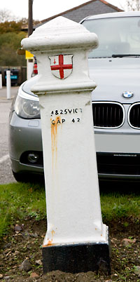
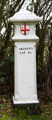
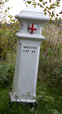
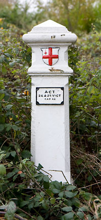
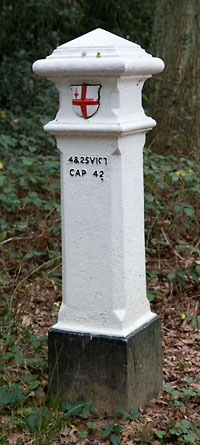
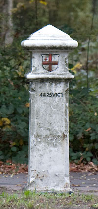
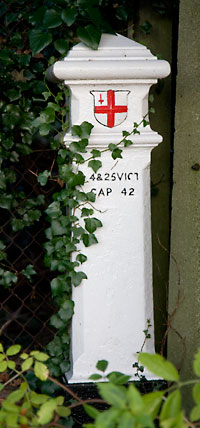
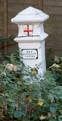
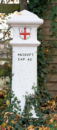
But where exactly did London start? This was not the time for the big "C" Congestion charge signs, but "coal tax posts". Different times required different taxes for different projects and in 1861 it was coal and wine to fund projects such as building of the Thames Embankment. Of the over 200 posts marking out the London District/Metropolitan Police District boundary, 11 were placed in and around Ashtead, at least 9 of which still remain.

The markers are white with a raised shield is the coat of arms of the City of London bearing the red Cross of St. George and Sword of St. Paul. The raised letters refer to the London Coal and Wine Duties Continuance Act, 1861. The [2]4 and 25 refer to the 24th and 25th years of Queen Victoria's reign and chapter 42 of the Statute book.

So the next time you go for a walk and encounter one of these think wine, coal, and tax! Don't worry the Act was abolished in 1889.

3' cast-iron post
TQ16642 59950West side of Kingston Road outside "The Star" public house
Historic England: Coal Duty boundary post outside The Star Public House
TQ17261 60145North edge of Ashtead Woods ½ mile south of Rushett Farm
Historic England: Coal Duty Boundary Post approximately 500 metres east of the road and 650 metres south of Rushett Farm, at the edge of Ashstead Wood
TQ17815 60649Edge of Ashtead Woods 500 yards southeast of Rushett Farm
Historic England: City of London Corporation Boundary Post at TQ 178606
TQ18299 61175not foundNorth side of Christ Church Road in Stew Pond Valley, slightly west of opposite of car park entrance
Historic England: COAL TAX POST TO WEST OF WEST PARK HOSPITAL
TQ18181 61194Near Old Glanmire Farm, on south side of Rushett Lane / Christchurch Road
Historic England: COAL TAX POST TO EAST OF GLANMIRE FARM
TQ18105 60915Near Woodcock Corner, 250 yards south of Old Glanmire Farm
Historic England: City of London Corporation Coal Duty Boundary Marker at TQ 181609
TQ19416 59399North side of Dorking Road/Epsom Road
Historic England: COAL TAX POST AT TQ 194 594
TQ19867 58314East side of Pleasure Pit Road, just south of Headley Road
Historic England: COAL TAX POST NEAR JUNCTION WITH HEADLEY ROAD
TQ20039 57903West of Headley Road beside footpath by stables
Historic England: COAL TAX POST AT TQ 200 579
TQ20116 57429Junction of Headley Road and Langley Vale Road
Historic England: COAL TAX POST AT JUNCTION WITH LANGLEY VALE ROAD
14' granite post
TQ19298 59657
        with train behind

 
South of railway immediately to the east of the Rye on Epsom Common
Historic England: COAL TAX POST ON RAILWAY EMBANKMENT TQ 193 595


Acts
Coal Duties (London & Westminster and adjacent counties) Act 1851 - Originally erected roughly twenty miles all round London
London Coal and Wines Duties Continuance Act 1861
London Coal Duties Abolition Act 1889

See also Local Places to Visit
See also Proceedings of the Leatherhead & District Local History Society Vol. 5 No. 4, 1991
See also Peter Tarplee's book A Guide to the Industrial History of Mole Valley District
See also City Posts - The coal duties of the City of London and their boundary marks. An excellent and most comprehensive site
See also City of London - Coal tax posts
See also Location of Coal and Wine Tax Posts within the [Elmbridge] Borough
See also Coal and Wine Tax Posts - Epsom and Ewell
See also The City of London Coal Duties and their boundary marks by Maurice Bawtree
See also BBC Radio 4 Making History programme 13: 23 December 2003

A precis of this article first appeared in Ashtead at Christmas 2007


If it's photographs you're after try my other site PhotoswithStyle

PwS banner